
The Iron Lady of India had a lot to be grateful for to Chikmagalur. Had the sleepy little town not voted her back into power in 1980, Indira Gandhi would have remained in the political wilderness because of the Emergency. Earlier, probably in 1650, a Sufi saint planted the first coffee saplings in the district and helped create India’s finest coffee estates. These plantations in turn were nurtured and expanded by the British in the 19th and early part of the 20th century. Today, Indian planters and corporations own hundreds of acres of arabica and robusta plantations that cover the slopes of the hills. Pepper vines entwine over the silver oaks that provide shade to the coffee shrubs.

Baba Budan Hills (Photo by Motographer)
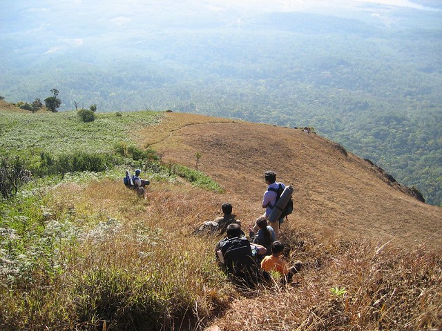
This is the district where the crescent-shaped Baba Budanagiri Range stretches for 80 km, rising majestically to an average height of 1,500- 1,900m and blending seamlessly with the Western Ghats, designated as one of the 25 biodiversity hotspots of the world. This is the free range of the endangered tiger, bonnet macaque, gaur, elephant, spotted deer and nilgai. Over 250 bird species, over 300 precious medicinal plants and herbs, orchids and flowers and varieties of bamboo and timber trees flourish here. This is also the home of the great Bhadra River that begins as a series of streams on the hills and then tumbles onto the plains. The Jagara Valley nestles between these hills.
A folk song of the area captures the spirit of the place in these words: ‘If the bamboo swings to the voice of the wind and the tiger wanders with gaiety, then it must be Jagara Valley.’ Trekking in these hills is sheer joy. In a matter of a few hours, one experiences a microcosm of the evolutionary tableaux, from the lichens and moss that cling onto the rocks to the dry deciduous sholas and grasslands. Carry water as one tends to get dehydrated during the trek. You can drink from the crystal clear springs when you reach higher ground. Carry salt to rub on leeches to get rid of them
DAY ONE
CHIKMAGALUR-MULLAIYANAGIRI
DISTANCE 14 KM TIME 3-4 HOURS
LEVEL EASY
Take any bus from the Chikmagalur Bus Station towards Kemmannagundi, and just 6 km down the road, get off at the arch that says ‘Sarpanadari’, literally, the trail of the snake. It will be better still to begin your trek from the town itself, heading north on the state road leading to Kemmannagundi. After 3 km, the road begins to twist and ascend. Coffee estates dot the hillside. Another 3 km and the ‘Sarpanadari’ arch beckons you to the left. There’s a signboard that indicates the trail leading to the Mullaiyanagiri Peak (1,925m).

Mullayanagiri Peak (Photo by Riju K)
Avoid the motorable road that takes you three-fourths of the way to the peak. Instead, hit the trail on your right. You’ll crest the first hill adorned with slippery rocks, bamboo and thorny shrubs in 45 mins. Take a breather and a swig of water. There’s a plateau extending before you for about 30m. Cross it and the next hill towers 450m. The gradient now is around 45-40 degrees. Keep climbing and half-an-hour later, you’ll come to a narrow ridge that provides panoramic views of the plains and the Chikmagalur town and villages far below. You’ll also find laterite caves en route with colonies of bats. Follow the path as it winds uphill.
At 1,500m, one reaches a piece of level ground, the size of a tennis court and there, before you looms the Mullaiyanagiri Peak with a Shiva Temple crowning the top. Climb the 50-plus shaky stone steps and you can have a darshan of the deity. Camp here in a tent, in the caves or in the courtyard of the temple. The hill is especially memorable in the monsoon when winds reaching 60- 80 kmph whip across the hill and the rain slices into the cliff face. On a clear summer day, the 8-9 km route (depending on how you traverse the hills) will take you a little over 2 hrs to cover, but in the monsoon it could take over 3 hrs.
DAY TWO
MULLAIYANAGIRI-BABA BUDANAGIRI
DISTANCE 18 KM TIME 6-7 HOURS
LEVEL EASY WITH SOME STEEP CLIMBS
Kemmannagundi is to the north-west of Chikmagalur, separated by the Baba Budanagiri Range. Mullaiyanagiri, the highest peak, lies almost half-way along this range. The Baba Budangiri Dargah lies 18 km to the north-east. To reach there, descend a thousand metres to the north-east of the Mullaiyanagiri Peak and then walk to the junction of two trails that run almost parallel to each other. One is used by herdsmen who bring their cattle from the plains to graze on the grassy slopes, and the other by pilgrims and trekkers. There are signboards pointing north-east to the dargah.
You can camp anywhere near the dargah grounds or bunk down with the pilgrims in a large hall in the dargah complex. If you want comfort, taxi down to Nature Nirvana Plantation Getaways (Tel: +91-98440-42152/+91-94483-64159; email: naturenirvana @yahoo.com/ naturenirvana.com), which is 15 km away in the Byne Khan and El Dorado coffee plantations.
Trek to Baba Budanagiri (Photo by Sai Sreekanth Mulagaleti)
DAY THREE
BABA BUDANAGIRI-KEMMANNAGUNDI
DISTANCE 14 KM TIME 4-5 HOURS
LEVEL EASY
Kemmannagundi is 14 km away to the north-west, but you first go around the shrine anti-clockwise and head south-west. You’ll spot the trail easily. It leads through lush coffee estates and scrub forest, through large bare crevasses made by strip mining and then up north-west to the Kemmannagundi Hill Station (1,434m), made popular by Raja Krishna Rajendra Wodeyar IV, who spent his summers here in the 1930s. Because of this association with the king, Kemmannagundi is also referred to as Sri Krishna Rajendra Hill Station, or simply KR Hills. The king built himself a summer palace at Kemmannagundi, which he later donated to the state government, along with his land here. You can camp at the Kemmannagundi maidan. Or stay in any one of the little 2-room lodges on the main road, which also claim to serve “brakfast”. The hilltop Horticulture Department Guest House offers five cottages.
DAY FOUR
KEMMANNAGUNDI-BHADRA WILDLIFE SANCTUARY
DISTANCE 12 KM TIME 3-4 HOURS
LEVEL EASY
From the hill station, a number of trails head north-west to Z Point, a rocky promontory 3 km away, where one gets a panoramic view of the jungles covering the Western Ghats. To the left of Z Point, you’ll spot a path. Trek along this steep and narrow path and after 5 km, you’ll hear the booming sound of the 160m Hebbe Waterfalls. In the old days, hundreds of prisoners of the chieftains and kings of the region were pushed over the falls to their death, on the rocks in the rapids below. Keep walking past Hebbe and climb another 2 km and you’ll witness the 122m cascade of the Kalhatti Falls.
As you approach there, you’ll spot a temple through the cloud of spray, nestling in the cliff over which the water tumbles. This should take you about 2 hrs. Refresh yourself in the cool water and march for 11/2 hrs parallel to the state road that takes off from near the falls and leads to the hamlet of Muthodi and the Bhadra Wildlife Sanctuary. Camp at the Muthodi Nature Camp grounds or stay in their cottages or in the dorm. Join a safari to the sanctuary the next morning. Head home by the bus or taxi service available here for Chikmagalur.

Hebbe Falls (Photo by sanjibm)
Healing touch of Coffee
The Imam Dattatreya Bababudan Swamy Dargah is a cave shrine in the lower reaches of the Baba Budanagiri Range, 32 km from Chikmagalur by the state road. Legend has it that Hazrat Dada Hayat Mir Kalandar, a Sufi saint, arrived in these parts in the 1650s from Mecca, where he had gone on a Haj pilgrimage. There, in the cities of Arabia, he had tasted the popular aromatic coffee made from beans brought from Ethiopia. He collected seven beans and on his arrival in the hills, planted the seeds and nurtured the saplings. Soon he was cultivating a couple of acres on the hills and the brew caught the imagination and taste buds of the populace.

Dried and roasted coffee beans (Photo by Big Eyed Sol)
The saint was a teacher and healer who lived in a humble home in one of the laterite caves in the hills. His teachings, combined with his generosity with the refreshing brew, resulted in him being called Baba Budan, the saint who heals. No one is quite sure how the cave where he lived also came to be known as the abode of Dattatreya, an incarnation of Brahma, Vishnu and Shiva. What is certain is that both Hindus and Muslims have been worshipping this spot ever since the demise of the saint. The Muslims called him a disciple of the prophet while the Hindus considered him a reincarnation of Dattatreya. The shrine also spawned a syncretic belief that became an integral part of the region — the awadhut tradition that upholds a formless god and condemns caste and sacrificial rituals.
By Allen Mendonca
About the author: Allen Mendonca is a Bangalore based writer, columnist, actor and musician. He served in senior positions in a number of national dailies before deciding to travel to wherever his dreams take him.

