
To drive on Sikkim roads in peak monsoon is asking for trouble. Torrential rain, of which this region sees plenty, practically changes the topography of the highways. Some adventurous tourists from the plains do brave these conditions but hill people like me are loath to travel during the monsoon. This time, however, I didn’t have much of a choice. I was on an assignment to drive from Siliguri to Gangtok and onto Cooch Behar (Koch Bihar), a driving holiday that seemed destined to be grounded even before day one, what with inclement weather and political turmoil making a mockery of my travel plans.

Siliguri (Photo by timabbott)
We were to start in the second week of June but a political outfit declared a bandh in Darjeeling, demanding statehood for the region. We finally managed to set off in July, after the rain gods had seemingly gone on a break and the bandh was called off. As we left Siliguri and headed towards the hills, ominous signs appeared. Dark clouds lurked in the distance and within minutes, the first raindrops beat a tattoo on the hood of our jeep, a Tata Spacio with a 4-wheel drive. The rain did let up after some 10 km above Rohini, a village in the foothills surrounded by tea gardens. We stopped for a breather and ended up gasping at the views: the tea gardens of Rohini and Panighatta stretching below and the muddied waters of the Balason River in the distance.
From there, we headed towards Kurseong, fingers tightly crossed as we occasionally sneaked a glance at the skies. Located at an altitude of 4,864 ft, Kurseong is home to many a public school established by the British, and is now a hill station in its own right. As we drove into town, students wearing different school uniforms hurried home. Then came the steam-run Darjeeling Toy Train, which rolled into the railway station bang in the middle of the town. As we watched in awe, we noticed that the traffic policemen were not only directing the vehicles on the road but also the train! Our stop for the night was the lovely bungalow at the Selim Hill Tea Estate, and it was dusk when we reached there. We explored the estate the next morning, and after several steaming cups of tea picked from our beautiful surroundings, drove on to Darjeeling, which was well and truly in the grip of the monsoon.

Darjeeling (Photo by Jay Seedy)
After some sightseeing, we headed to the next port-of-call on our itinerary: Pelling, in West Sikkim. The rain now came down with renewed vigour. A fog stalked our jeep all the way to Lopchu, where the sun broke through the clouds and became a much needed ally. At Pelling, I woke up the next morning to the by-now unsavoury sound of rain falling on nearby hotel rooftops. We visited the Pemayangtse Monastery and then drove up to a hill on the opposite side to the Sanghak Choeling Monastery. The mud and slush on the road put an end to our drive, however, as the vehicle couldn’t go any further. We stopped the jeep, and hiked up the remaining few kilometres up the hill – a 45-min trek – to the monastery. Perched on the ridge of a hill above Pelling, Sanghak Choeling is the second oldest monastery in Sikkim. Built in 1642 but looking quite new because of the renovation in 1965, this small monastery is not as famous as its counterpart on the far side of the ridge. But antiquity aside, one good reason to visit is the view. A lone dhaja (prayer flag) fluttered beside a sang poe (incense altar) in the courtyard. A white chorten (pagoda) stood sentinellike on the southern flank as a smaller chorten kept watch on the western slope. Lungtas (smaller prayer flags) billowed in the wind above a slope that disappeared into a cloak of white mist.
Ruins of a former capital
Our next stop was the second capital of Sikkim at Rabdentse, a 10-min drive from Pelling. To reach the ruins of the erstwhile capital, we had to walk on a cobblestoned path through pine forests. At some points, the branches of the thick undergrowth reached across and formed a canopy of sorts overhead. Every now and then, a signboard appeared beside the path, egging us on. When we finally reached the spot, we saw that the ruins had been immaculately maintained. The grass was well cut, the flowerbeds cleared of weeds and the ramparts of the fort and the inner maze-like structures looked anything but ruin-like. The next morning, we headed for Yuksom. The road wound downhill and half an hour later passed through the picturesque village of Darap.
Fields of maize gave way to paddy in the terraced fields around us. A waterfall next to the road serenaded us. As we drove on, the roads became narrow but that didn’t seem to deter other vehicle drivers from speeding. We almost had a head-on collision with a truck coming downhill at breakneck speed. I watched with horror as the rear wheels of the oncoming truck screeched to a halt, missing us narrowly. The driver, a boy barely out of his teens, smiled at us as his truck passed us. Mishap averted, we had a leisurely hour-long ride to Khecheopalri Lake, held sacred in Sikkim as a ‘wishfulfillment lake’. Although the lake is surrounded by woods, not a single leaf is to be seen floating on the water. Legend has it that the birds in the lake, especially the ducks, diligently remove the leaves. As we looked around at the placid, clean waters of the lake, mist started closing in from the far end. The rain continued incessantly.
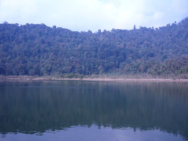
Khecheopalri lake (Photo by spaceppl)
We drove on to Yuksom, stopping to marvel at the waterfalls en route, a perk of travelling in the monsoon. During the drier seasons, these waterfalls are nowhere at their roaring best. We rolled into somewhat sleepy Yuksom, also the hub from where trekkers start the Tsokha-Dzongri- Goecha La trek in the season from October to April. But for now, locals had the place to themselves. They gave us quizzical looks, probably wondering what we were doing there in the rains, when they themselves had been almost boxed in by landslides, as we would find out later.
The road to Gangtok via Tashiding had been wiped off in the rains. It was an unexpected roadblock, one we could tide over only by retracing our way to Pelling and then heading to Gangtok from there. Deciding to explore Yuksom in the meantime, we hiked to Dubdi Monastery, situated on a hillock, said to be Sikkim’s oldest monastery. As we walked through the woods above Yuksom, it became clear that we would have some unsavoury company in the form of leeches. On our way down, we stopped to look up at the monastery: dark rain clouds were closing in over the mountaintops and the view was spectacular. The disappointment of having to retrace part of the drive from Yuksom was almost mitigated that evening, when our hosts at the hotel served us the local millet beer (chhang) in bamboo mugs. Dinner was a sumptuous spread of rice, curries, pickles and maku, local cheese cooked in butter with a sprinkling of salt. Thus pampered, we were all set for the rest of the drive. Back on the road the next morning, we retraced our way to Pelling and then onto Melli, a bazaar beside the highway with some eateries. Now we would have the swollen Teesta River for company for the next hour or so. After a brief stop at the border town of Rangpo, we reached Gangtok in the evening.

Gangtok (Photo by Drmarathe)
On an old trade route
The next day, we were off to Nathu La (14,140 ft), after hiring a jeep with a local driver for the day. The Gangtok-Nathu La Highway is part of an old trade route from India to China. Till the 1960s, mule caravans used to ply this route carrying supplies. There’s a steep stretch just below Karponang, 15 km from Gangtok, and many a mule and sometimes even traders are said to have slipped and fallen down thousands of feet into the ravine below. We seemed set to emulate that journey of olden times, a tad too faithful to some of the unpleasant details for our own good. Just as we started our drive to the India- China border, a jeep speeding downhill missed crashing into us by a hair’s breadth. The sideview mirror, however, took a hit, and shards of broken glass flew all over the driver’s seat. Luckily, no one sustained any cuts. Soldiering on, we stopped for some tea at Kyongnosla, where our driver for the day had to show his permit at the police checkpost. When we reached Tsomgo Lake, which falls en route to Nathu La, it started raining.
After passing through several checkposts, we reached the parking lot at Nathu La, from where we had to climb steps to the border. Every now and then, we stopped to catch our breath. A two-storeyed building in brick red came into view in the mist and suddenly we were there – at the border. When we climbed down, there was the sound of distant thunder, and the rain battered the jeep all the way to Gangtok. The next morning, we heard that violence had once again erupted in Darjeeling and Kalimpong. Although we had been told that the situation was under control, no one was sure what would happen. We headed on to Kalimpong, which looked normal but was eerily quiet. The next morning, we made an early start for Lava but were waylaid by a flat tyre. We took a break to have breakfast at a restaurant, where the hotelier told us that Lava was fast becoming a tourist destination because of its proximity to the Neora Valley National Park and the views of Jelep La (14,390 ft) and Rechi La (10,370 ft) it offered. But all we saw was a thick curtain of fog, in which Lava was wrapped. The fog became more dense as we drove on to Dam Dim and as the visibility reduced to a few metres ahead, our speed dropped to 20 km per hour. The fog finally relented about 15 km downhill.

Nathula Peak (Photo by Vinay.vaars)
At Phaparkheti village, the hills gave way to the gentle slopes of the Ambiok Tea Estate and Gorubathan’s Sombaray Bazaar. We then drove into the Dooars, the flood plains and the foothills of the Eastern Himalaya, which was once Bhutanese territory and was annexed by the British in 1865. Now a part of West Bengal and Assam, these plains are watered by the innumerable mountain streams and rivers that flow from Sikkim, Bhutan and Arunachal Pradesh, making it one of the most fertile regions in the North-East. Driving through tea, paddy and jute As we drove on past Dam Dim on NH31, tea gardens flanked us on both sides of the highway. Malbazaar flashed by and other nondescript little bazaars and small towns. It took the whole day to get to the Jaldapara Wildlife Sanctuary, our next halt, but the place we were spending the night was further ahead. After passing through a couple of forest checkposts and driving on a dirt track, we reached the Chilapata Jungle Camp.
After breakfast the next morning, we decided to turn south towards Cooch Behar, the seat of the princely state of Koch Bihar during the reign of the Koch dynasty. The road was good; we reached there in 45 mins. We headed straight to Koch Bihar Palace, whose bright, brick red and white façade was visible even from the massive wrought iron gates some 300m away. Our next stop was supposed to be the India-Bhutan border at Phuntsholing but by the time we neared Hasimara en route it was 4.30 pm, too late to drive on. We, therefore, were forced to head back, promising ourselves that we would visit during our next drive to these parts.

Phuentsholing (Photo by logjayge)
The next day we headed back to Siliguri on NH31. On both sides of the highway, lush green fields of paddy and jute stretched to the horizon. People ferried cartloads of golden fibres of jute – some of which had already been harvested – to the market. A jute auction went on beside the highway near Falakata. As always in the monsoon, the countryside was abuzz with activity. Paddy fields were being tilled, bullocks were ploughing the fields, and women and children were fishing in the ponds. For all my hang-ups about travelling in the rains, I was glad I’d done this drive in the monsoon.
ON THE ROAD
No special permit is required for either travelling or trekking inside Darjeeling. However, do remember that travel documents such as ID cards and driving licences may need to be shown as and when required. In addition to an Indian visa, foreigners have to obtain an Inner Line Permit (ILP) to visit Sikkim. Apart from identification papers such as ID cards or voter cards and a driving licence along with vehicle papers, Indian citizens do not need any special permit to travel to Darjeeling, Kalimpong, Gangtok and Nathu La.
It’s advisable to stock up on petrol before leaving Siliguri given the uncertainty of the political situation. Strikes can paralyse Darjeeling. There are petrol pumps, puncture repair shops and garages at Sonada (45 mins from Kurseong) and Ghoom (30 mins from Sonada and 15 mins from Darjeeling). A service station can be found only at Darjeeling. There are no dhabas in these hills. At Sonada and Ghoom, you’ll find restaurants, tea stalls and provision stores. There are three roads from Siliguri to Kurseong, of which the road through Pankhabari is now a one-way road, open only to downhill traffic. It’s also very steep with hairpin bends. The road via Rohini is the route taken by most light vehicles. But for some kilometres out of Siliguri, you’ll find several stretches with potholes. The older highway via Tindharia with its British-era railway yards is the Hill Cart Road (NH55), used largely by buses and trucks. There are small bazaars on this route with tyre repair shops but there are no petrol pumps on any of the three routes.

Kurseong (Photo by timabbott)
The road out of Kurseong is full of potholes till Darjeeling. Except for a few rough stretches and some potholes between Darjeeling and Ghoom, the condition of the road till Pelling is generally good. But if you’re travelling during the rains, then you’ve to be prepared for landslides, sliding stones and roadblocks due to falling debris. Most of the road passes through mountainous terrain, which has its share of hairpin bends. The district roads are quite narrow, so do remember to honk at every bend and always maintain a safe speed.
Trip Facts
When to go: Between March and May and September and November. The tea gardens are best visited in summer, in the plucking period. We did this drive in the rains but it’s not at all recommended. Everything is covered in mist or fog and you won’t be able to enjoy much of the scenery. If driving in winter, remember that the days are much shorter and the mountains extremely cold after sunset. The army ensures the roads are open through the year. The Jaldapara and Buxa wildlife sanctuaries season for tourists is from September 15 to June 15. Best time for visiting the sanctuaries is from October to April.
What to wear:Carry warm clothing and wear sturdy shoes; you’ll have to hike.
Driving tips:Landslides will be a common feature in the rains. The worst affected areas will have warning signposts and General Reserve Engineering Force (GREF) personnel man these areas and clear the debris. At some places in Sikkim, the police also helps out in directing traffic. Do watch out for falling debris and heed the warning signposts and follow the GREF personnel’s directions. Whenever you’re driving, carry more than one spare tyre and fit your vehicle with fog lamps.

Darjeeling toy train (Photo by SupernovaExplosion)
Altitude sickness is a strong possibility, so be prepared. Note that while Gangtok is at 5,500 ft, Nathu La stands at 14,140 ft; so it’s best not to head to the pass just a day after reaching Gangtok. Try not to exert yourself much while heading to Nathu La.
STD codes:Darjeeling 0354, Gangtok 03592, Kalimpong 03552, Pelling 03595, Yuksom 03595
About the author:
Suraj Gurung is a Gangtok based travel writer and photographer who loves nothing more than heading out on lonely highways on his Royal Enfield.

