
If you are planning a holiday in Sangla and wish to throw in a bit of exercise and adventure, this short trek is ideal for you. This way, you can savour the beauty of the pastures of Sangla Kanda without the exertion of the Rupin Pass trek. Enjoy the Kanda over the afternoon after climbing up from Sangla. Spend the night at (or near) the Trekker’s Hut here and climb north-west the next day to cross the Shivaling Pass back towards the Baspa Valley. Once across, stroll down to the trekking hut at Dambar, the pasture of Chansu Village. If time is not at a premium, spend another night watching the moon over Raldang Peak, due north across the Baspa Valley. From Dambar take the steep track to Chansu Village and Ruttrang Bridge, to reach the motor road 3 km below Sangla.
DAY ONE
SANGLA-SANGLA KANDA
DISTANCE 10 KM TIME 4 HOURS LEVEL EASY
From the motor road at Sangla, various paths descend through the village. Cross the Baspa Valley by a sturdy footbridge below the Forest Rest House, located just above the Baspa left bank. From here, a footpath climbs steeply south-west through deodar and blue pine. The Baspa Valley is visible below till the crest of the ridge is crossed. Across is the famed expanse of Sangla Kanda (3,600m), sloping gradually from west to east before dropping sharply to the Rukti stream on the left. The Rukti, a left bank tributary of the Baspa, meets the latter just above Sangla near the hamlet of Anmoshiresh. The path continues south-west through single crop fields climbing gradually to reach pasture land as one approaches the head of the Rukti Valley. Shepherd shelters and a basic Trekker’s Hut are an alternative to camping out for the night — but the sheep droppings and mites make tents an infinitely superior alternative.
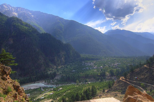
Baspa Valley (photo by Nikhil.Hirurkar)
DAY TWO
SANGLA KANDA-DAMBAR KANDA
DISTANCE 8 KM TIME 3 HOURS LEVEL EASY
From the camp at the upper end of Sangla Kanda, traverse north-west and back towards the Baspa Valley, along the grassy slopes of the mountain separating Sangla Kanda from the Dambar pasture of Chansu Village. Climbing gradually and curving north, the route ascends to the ridge crossing it at Shivaling Pass (3,980m). The pass overlooks the spread of the Sangla bowl below. Across, further south, is the panorama of the Kinner Kailash Range with Raldang’s sharp spire (5,499m) most prominent. The descent north to Dambar Kanda is not very steep and the Trekker’s Hut (not in good shape) at Dambar Kanda (3,568m) is visible from the top.
DAY THREE
DAMBAR KANDA-SANGLA
DISTANCE 6 KM TIME 2 HOURS LEVEL EASY

Lake en route to Sangla (photo by Beverly)
The descent to Chansu Village, 800m below, is steep — but quickly accomplished by those with good mountain legs. Initially, along the grassy slopes, it enters steeper rock faces and scattered forest half-way down. The roadhead lies at Ruttrang Bridge, 3 km from Sangla, and just below the reservoir of the recently completed 300 Mw Baspa II Hydel Project. Sadly, it drains the Baspa of its might, and one can no longer experience the magnificence of its precipitous tumble below Ruttrang.
By Deepak Sanan
About the author: Deepak Sanan is an IAS officer, Himachal Pradesh cadre, who has trekked extensively in the state. His writings include a book on exploring Kinnaur and Spiti, as well as numerous articles about Himachal in magazines and books.

